Climate of Colombia

Factors
Factors that specifically determine the climate of this land can be classified by geographical and atmospheric: HI :D
Geographical
The geographical factors are determined by latitude or altitude. Colombia is crossed by the equator in its southern part, but the majority of the territory is part of the northern hemisphere and within the torrid zone which is characterized for receiving direct sunlight throughout the year. A considerable area of Colombia is mountainous, mainly crossed by the Andes mountain range from south to north.
Altitude in this mountains counter rest the effects of the latitude characteristics producing gradual variable climates from tropical foothills and coastlines to perpetual snow peaks. In Colombia these are classified as "thermal floors" (Spanish: Pisostérmicos).
The Sierra Nevada de Santa Marta is an example of the variety of climates present in Colombia; From the warm sea level to gradually descending temperature of perpetual snow peaks at 5,775 meters over sea level.
Colombia is also bordered by two massive oceans, the Pacific and the Atlantic (through the Caribbean sea) which force the humid winds to pass over Colombia with humidity and rainfall that is contained by the Andes and other mountain ranges, that is the case of Lloró in Chocó Department which is one of the rainiest lowlands in the world.
The contrary occurs with the trade winds from the northeast that also crosses Colombia penetrating without any mountainous ranges the valleys of the Magdalena and Cauca rivers, and also the trade winds from the southeast that cover the Amazon region only blocked by the Andes mountains.
In the case of the Guajira Peninsula plains, the trade winds are unable to be stopped (despite having a low altitude range of mountains; the Serranía de Macuira) and continue traveling inland towards Colombia's central regions, for this reason the Guajira area present a dry climate and produced the Guajira desert. For this reason the numerous mountains present in Colombia produce a varied climate and subregions.
Atmospheric
The atmospheric factors are determined by temperature, humidity and winds. The temperature is relatively average throughout the year in a same place. The tropical location of Colombia and the uniform solar radiation for being in the equator gives this country an almost constant temperature. The atmosphere varies due to the altitude in the mountains and its proximity to sea level.
Humidity in Colombia is diverse and is characteristic of each region and subregion. This is produced by altitude, temperature, vegetation and water presence. The Pacific, Amazon and Orinoquía regions are the rainiest and the lowest and dries are in the northern part of the Caribbean region, in Uribia, Guajira in the Guajira desert.
Mountains holding clouds in the Pacific region.
Winds are produced by differences between atmospheric pressure and temperature and the winds that impact the most Colombia are the trade winds. Trade winds pass Colombia from different directions, trade winds from the northeast carry humidity to the region south of the equator and also carry rain to the rest of the country while the trade winds from the southeast carry humidity and heat to the northern hemisphere side of Colombia. The winds coming from the Pacific Ocean modify the climate along the western coast of Colombia producing abundant precipitation year rounds.
Climate zones
The diversity of climates in Colombia is characterized for having tropical rainforests, savannas, steppes, deserts and mountain climate, this last one further subdivided into tierra caliente (hot land) tierra templada (temperate land) tierra fria (cold land), tierra helada (frozen land) and Páramo.
Tropical rainforest
The tropical rainforest climate is characterized by hot and high humidity climate along with heavy rainfall mostly present in the jungles of the Catatumbo, the Amazon river basin the central region of the Magdalena River, the pacific coast, the Serrania del Perija and others.
Tropical savanna
The semi-humid tropical savanna climate is characterized for being between 24°C and 27°C with a variation in climate of two seasons; a rainy season and a dry season (produced by the trade winds from the northeast) each enduring a period of six months. Regions in Colombia with this climate characteristic are the Llanos (eastern plains), some section of the Caribbean plains near the coast, sections of the Magdalena and Cauca river valleys.
Steppe
The steppe climate is characterized for having a very few vegetation limits and minimum precipitations and can also include the desert climate for a period of 5 months of dry season. This type of weather is characteristic of the plains of Bolivar and the northern Guajira (Serranía de Macuira), the central area of the Orinoquía region and the higher grounds of the Andes mountain range.
Tropical desert
The Tatacoa Desert.
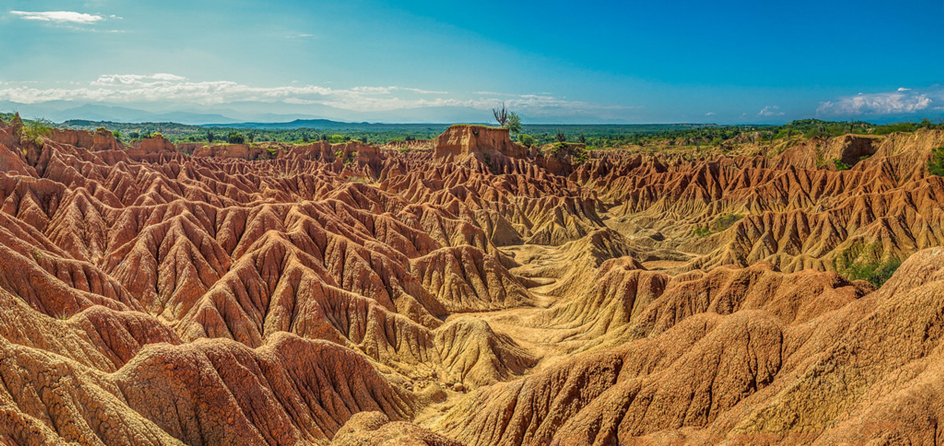 The desert tropical climate in Colombia is present in the Guajira and Tatacoa deserts characterized for their high temperatures and scarce precipitations. The trade winds from the northeast carry humidity from the oceans and without a mountain barrier nearby continue flowing without dropping any rainfall and eventually creating droughts.
Tropical mountain climate
Mountain climate is one of the unique features of the Andes, the Sierra Nevada de Santa Marta and other high altitude reliefs where climate is determined by elevation. These variations in climate depending on its altitude are called thermal floors (Spanish: Pisos termicos), a classification used in some countries but with variations in the classification of each floor.
Warm climate thermal floor
The warm thermal floor oscillate between sea level to a 1,000 meters over sea level with a temperature over 24°C. Climate in this step is characterized for its similarities with the equatorial and tropical plains, heavy rains and high temperatures. Temperatures can reach over 29°C as it is the case of the Magdalena river valley, which has many areas with jungles. This thermal floor is present in the cities like Santa Marta, Neiva, Cali and Cucuta.
Representation of the "thermal Floors" present in a mountain climate.
Temperate climate thermal floor
Between a 1,000 and 2,000 meters over sea level the temperature drops oscillating between 17°C and 22°C defining it as a temperate climate. Rainfall becomes variable at 1,700 meters over sea level and rains between 2,000 mm³ and 2,500 mm³. This climate is a characteristic in the cities like Pereira, Armenia, Ibague Popayán and Medellín.
Cold climate thermal floor
The cold climate is present between 2,000 and 3,000 meters over sea level and is characterized for having Andean or cloud forests. This thermal floor is characterized for presenting an average temperature ranging between 10°C and 17°C while rainfall reaches a yearly average of 2,000 mm³. The Colombian capital city Bogotá is located within this thermal floor. Other cities like San Juan de Pasto and Tunja are in this location.
Paramo climate thermal floor
The Páramo climate is present between 3,000 and 4,000 meters over sea level and the temperature is lower than 10°C with gelid winds, few rainfall but frequent snowfall. Colombia has one of the largest páramo areas in the world; the Páramo of Sumapaz located in central Colombia, over the Andean Cordillera Oriental branch. In Colombia páramos are further classified as subpáramo, páramo and superpáramo. Most of the rivers in Colombia are born here since páramos tend to hold water from precipitations and deglaciations coming from the peaks.
Glacial climate thermal floor
The glaciers in Colombia are located over the 4,000 meters over sea level and up and with average temperatures ranging between 10°C and below. Glaciers in Colombia began retreating in the 20th century due to global warming and are in danger of disappearing, if this occurs water supply would be scarce in the near future. Most of the glaciers are located in the Andes mountains and are inhabited by very few living species due to its sever weather.