Water source of Azerbaijan
The hydrography of Azerbaijan basically belongs to the Caspian Sea basin.
Rivers
Rivers form the principal part of the water systems of Azerbaijan. There are 8,359 rivers of various lengths within Azerbaijan. Of them 8,188 rivers are less than 25 kilometers in length.
Only 24 rivers are over 100 kilometers long. The largest rivers that flow through the country are:
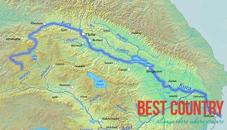
Kur
Araz
Ganikh, located in Alazan
Qabirri also known as Iori
Samur
Pirsaat
Tartarchay (tributaries Levçay, Ağdabançay, Turağayçay)
Turyan
Agstafa
Hekeri
Vilesh
River system
The rivers in Azerbaijan can be divided into three groups:
The Kur basin rivers (Qanix, Qabirri, Turyan, Agstafa, Shekir, Terter, Khachin, etc.)
The Araz basin rivers (Arpachay, Nakhchivan, Okhchu, Hekeri, Kondelenchay, etc.)
Rivers, flowing directly into the Caspian Sea (Samur, Gudyal, Velvele, Vilesh, Lenkeran, etc.)
Azerbaijan river systems are changing and evolving under the influence of various physiographic factors: climate, landscape, geological structure, soil and vegetation.
The density of the river network increases, then gradually decreases later with higher altitudes. Except for the Talysh region (1.6-2.2 km/km²), the river system density is the highest (1-2 km/km²) at 1,000-2,500 kilometers, while in the area of the Talysh mountains it peaks at 1.6-2.2 km/km² at 500-1,000 km.
The average density of the river system of Azerbaijan is 0.39 km/km². The density is even lower than 0.05 km/km² in the plains.
Kura and Aras
The Kura and Aras are the most popular rivers in Azerbaijan, they run through the Kura-Aras Lowland. The rivers that directly flow into the Caspian Sea, originate mainly from the north-eastern slope of the Greater Caucasus and Talysh Mountains and run along the Samur-Devechi and Lenkeran lowlands.
The Kura River basin area (86,000 km²) up to the junction with the Aras River is smaller than the Aras water basin (101,937 km²). The river is still called Kura on the junction because the water level of the Kura is twice as high as that of the Aras River.
Lakes of Azerbaijan
Jandargol
Lake Hadjikabul - the largest lake of the Azerbaijan (after the Caspian Sea)
Lake Boyukshor
Lake Sarysu
Lake Goygol
Nohur
Maral-gol
Masazirgol
Ajinohur
Boyuk Alagol
Reservoirs of Azerbaijan
Over 60 water reservoirs have been constructed in order to regulate the river flow in Azerbaijan.
The formation of these reservoirs is one of the measures that has been undertaken in order to ration the utilization of water and energy resources. The largest water reservoirs are:
Mingachevir reservoir
Shemkir reservoir
Araz reservoir
Serseng reservoir
Agstafachay reservoir
Varvara reservoir
Jeyranbatan reservoir
Khanbulanchay reservoir
Yenikend reservoir
The reservoirs in Azerbaijan are designed to be utilized for various purposes, while most other ponds are used exclusively for irrigation.