Geography of Azerbaijan
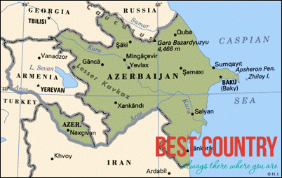
The total length of Azerbaijan's land borders is 2,648 km (1,645 mi), of which 1007 kilometers are with Armenia, 756 kilometers with Iran, 480 kilometers with Georgia, 390 kilometers with Russia and 15 kilometers with Turkey. The coastline stretches for 800 km (497 mi), and the length of the widest area of the Azerbaijani section of the Caspian Sea is 456 km (283 mi). The territory of Azerbaijan extends 400 km (249 mi) from north to south, and 500 km (311 mi) from west to east.
Three physical features dominate Azerbaijan: the Caspian Sea, whose shoreline forms a natural boundary to the east; the Greater Caucasus mountain range to the north; and the extensive flatlands at the country's center. There are also three mountain ranges, the Greater and Lesser Caucasus, and the Talysh Mountains, together covering approximately 40 percent of the country. The highest peak of Azerbaijan is mount Bazardüzü (4,466 m), while the lowest point lies in the Caspian Sea (−28 m). Nearly half of all the mud volcanoes on Earth are concentrated in Azerbaijan, which is also among nominees for New7Wonders of Nature.
The main water sources are the surface waters. However, only 24 of the 8,350 rivers are greater than 100 km (62 mi) in length. All the rivers drain into the Caspian Sea in the east of the country. The largest lake is Sarysu (67 km²), and the longest river is Kur (1,515 km), which is transboundary. Azerbaijan's four main islands in the Caspian Sea have a combined area of over thirty square kilometer.