Bosnia-Herzegovina is a country in southeastern Europe.
Bosnia and Herzegovina, a country of the Balkan Peninsula. (In common usage—and in the remainder of this article—a hyphen is used instead of the word “and.”) Bosnia-Herzegovina is bordered by Croatia, Serbia and Montenegro. From 1946 to 1992 Bosnia-Herzegovina was a constituent republic of Yugoslavia. In 1992, it became independent.
Geography of Bosnia and Herzegovina
26/03/2020
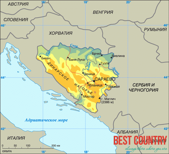
Bosnia-Herzegovina covers about 20,000 square miles (52,000 km 2 ).
The country is virtually landlocked, with only a 13-mile (21-km) coastline and no harbors. Lying mostly in the Dinaric Alps, Bosnia-Herzegovina is a mountainous country. Mount Plocno, which rises 7,310 feet (2,228 m), is the highest peak.
Major rivers include the Sava, Drina, Bosna, and Vrbas. About half of the country is forested.
Bosnia-Herzegovina's economy was severely damaged during the civil war period between 1992 and 1995. Industrial production was severely affected by the war and unemployment continues to be high. Many countries have pledged billions of dollars to rebuild its roads, railways, bridges and schools.
Its economy is based largely on agriculture.
Crops cultivated include corn, wheat, potatoes, tobacco, and fruits and vegetables. Bosnia-Herzegovina has many mineral resources, thus producing large amounts of copper, lead, zinc, and gold. Industry is associated mainly with the processing of agricultural products or minerals.