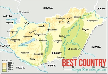
Geography of Hungary
Its capital is Budapest, divided by the River Danube: the serene, green hills of Buda on one side, and the flat, but vibrant cityscape of Pest on the other. Budapest is one of the most popular cities of Europe, and one of its top tourist destinations.
The second biggest city of the country, Debrecen, has been trending more and more in the past years due to its very own airport. Rural Hungary boasts many pleasant towns and a myriad of tiny villages which evoke the traditional culture of the country.
Hungary can be divided into 6 geographic regions:
- Alpokalja
- The Little Hungarian Plain
- The Transdanubian Mountains
- The Transdanubian Hills
- The North Hungarian Mountains
- The Great Hungarian Plain
As far as its economy, Western Transdanubia is the most advanced territory of the country. Sopron and Kőszeg are the most well-known historic cities of the border region of Alpokalja.
The Small Hungarian Plain is bounded by the watercourses of the Danube and Rába rivers, its centre is the historic baroque town of Győr.
The region of the Balaton Uplands among the Transdanubian Hills is famous for its vineyards, natural beauty and rural charm. Vines have been cultivated and wine has been made around the lake since Roman times.
The most popular and frequently visited part of the country is its central region, with the capital, Budapest.
Northern Hungary boasts many historically famous towns and fortresses, but is also renowned for the special species of grape used in making the world-famous wines of Tokaj and Eger.
Last but not least, the most traditional and unspoilt region of the country is the Great Hungarian Plain, where traditional lifestyles such as agriculture and livestock breeding remain to be the part of everyday life. This region takes up more than half of the country’s overall area. If you’re in Hortobágy, near Debrecen, you can observe the wonders of grassland fauna: flocks of sheep, herds of grey cattle and studs.
The horizon of the country is quite flat: most of its territory is below 200 metres (656 feet) below sea level. The highest point of Hungary is the Kékes mountain (1014 metres / 3327 feet) which lies in the Mátra range; it offers hiking trails in the summer and ski slopes in the winter. It has two major rivers, the Danube and the Tisza, both suitable for sailing and shipping. Its many minor rivers and lakes offer an exciting, yet original location for watersports and boating.
Hungary is a landlocked country, however, its renowned Lake Balaton is the largest lake in Central Europe and its often referred to as the “Hungarian Sea”. Lake Balaton is an ideal vacation spot all year-round, visited by bathers in the summer and winter sports enthusiasts in the winter.
Hungary is one of the 26 countries that comprise the Schengen Area, where citizens of the member states can travel around freely and unrestricted, without border control.