Water resources of Albania are abundant, almost in all the regions of the country, with an uneven seasonal distribution. The available quantity of surface water, and to a less extent of groundwater also, strongly decreases during the months of summer. Thus, only about 6-9 % of the annual runoff is observed during the dry season (July-September).
Water resources of Albania
18/08/2019
The mean annual precipitation in Albania are 1485 mm and the mean annual volume of water, discharged by all the rivers in the sea, is 41 km³ of water. It corresponds to a mean discharge of 1300 m³/s, aproximative with those of the Po river in Italy.
These water resources are mainly used for energy production, irrigation, industry, drinking water etc.
Climate and Rainfall
Albania is located at the northern part of the Mediterranean zone. In addition, the country combines a coastal plain in the West with fairly high mountains: the highest point reaches 2751 m at the triple border with Yugoslavia and FYROM, while many ridges exceed 2000 m in the northern, central and southern parts of the country.
The rain comes mainly with south-west winds and is affected by the relief. This gives a variety of climates and rainfall patterns in the different regions of the country.
Surface Water
The hydrographic basin of Albania has a total area of 43,305 km² from which only 28,748 km² are situated within the state territory of Albania. The rest, which belongs to the catchments of the rivers Drini and Vjosa, is situated in Greece, FYROM and Yugoslavia.
Albania is crossed by several rivers, in general East - West direction: Drini, Mati, Ishmi, Erzeni, Shkumbini, Semani, Vjosa are the most important ones.
The mean annual discharge of all rivers of Albania is about 1300 m³/s, which corresponds to a specific discharge of 29 l/s.km², one of the highest in Europe.
Surface water include also the natural lakes of Ohrid, Prespa and Shkodra, a multitude of minor lakes, and reservoirs built along the main rivers: at Fierza, Komani and Vau Deja along Drini river, Ulza and Shkopeti on the Mati river, and Banja on the Devolli river.
Several lagoons are situated along the sea coast, the main ones being the Karavasta, Narta and Butrinti.
The Drini River
The hydrographic catchment of the Drini has a total area of 19,582 km² from which 14,173 km² belong to the Drini itself and 5,187 km² to the Buna river. The Drini is formed by two main tributaries: the Drini i Zi, with a catchment area of 5,885 km², flowing from FYROM, and the Drini i Bardhe, flowing from Yugoslavia.
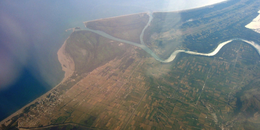
The Buna river drains Lake of Shkodra, which is fed by rivers originating from Montenegro and Albania; its larger tributary is the Moraça river.
In the past, the exits of Buna and Drini rivers have been separated. At present the old bed of the Drini, leading south to the city of Lezha, carries only a minor part of the discharge; the rest meets the Buna near Shkodra and follows its river bed along the border with Montenegro.
 The Drini river for the period 1951-1985 has a mean annual dicharge of 680 m³/s, of which 360 m³/s come from Drini itself and 320 m³/s from Buna. The resulting specific discharge is about 35 l/s.km² and the runoff coefficient 0.74.
These high values are mainly due to the very high yield of the Buna, which can not be much exploited - except for navigation. Keeping in mind the water use in Albania, the most important river is the Drini, with the following characteristics:
annual discharge volume: 11,1 km³
specific discharge: 24.8 l/s.km²
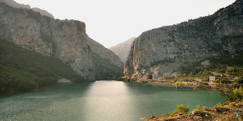
ratio wettest month (December) to driest month (August)one in 10 year high flow: about 13 times the river modul storage capacity of Fierza reservoir: 2,700 million m³ (about 25% of annual flow).
Chemical analyses of samples taken from the Drini showed a good quality water, with stable mineral composition along the river course.
Metallic ions are present in small amounts except for iron in some cases. It appears that no restriction for the present uses ( hydropower, irrigation) could arise from the water quality in the Drini.
A more difficult situation arises from the quality of the Kiri water, affected and possibly contaminating the local groundwater ressources also. Its effects on the lake of Shkodra have not been clearly assesed.
The Mati River
 The catchment area of the Mati River has a surface of 2441 km². The main tributary of the Mati is the Fani that flows from the north east, while the Mati itself from the south west down to the confluence with the Fani and then to the West. The Fani has a catchment area of 1076 km² and is formed by two tributaries: Fani i Madh and Fani i Vogel.
The Mati for the period 1951-1985 has a mean annual discharge of 103 m³/s, of which 60 m³/s come from the Mati itself and 42 m³/s from the Fani. The resulting specific disharge is about 40 l/s.km² and the runoff coefficient 0.75; these values apply for both Mati and Fani rivers. Here follows some basic characteristics:
- annual discharge volume: 3,250 million m³ ,
- specific discharge: 40 l/s.km²,
- ratio wettest month (December) to driest month ( August): 10,
- one in 10 year high flow: about 25 times the river module,
- storage capacity of Ulza reservoir: 240 million m³ (about 15% of annual flow of the Mati).
Chemical analyses of samples taken from the Mati before 1990 showed a high content of metallic ions (iron, manganese and copper), which is not surprising in an important mining area. It appears that for some uses ( hydropower, industry) these characteristics should not cause problems, while the impact on irrigated agriculture is not fully assessed and the implications for marine coastal waters are also not clear.
The Erzeni and Ishmi Rivers
The Erzeni-Ishmi basin is composed of the catchments of the Erzeni and Ishmi rivers and other minor ones, with a global surface of 1439 km². This basin is characterised by a mean altitude lower than in adjacent catchments; indeed springs are not at high altitude and the part of the water curses in the plain is long.
The Ishmi catchment has a particular importance for Albania because it includes the biggest urban center: Tirana, the capital of Albania. Basic characteristics are as follows:
- annual discharge volume: 660 million,
- specific discharge: 31.5 l/s.km²for the Ishmi and 24 l/s.km²,
- ratio wettest month (January-February) to driest month (August): 9 to 10,
- one in 10 year high flow : about 55 times the river module,
- storage capacity on either river: none.
Chemical analyses taken from the Ishmi before 1990 showed high values for many parameters ( iron, manganese,nitrates, suspended solids, BOD5 ).
This is not surprising since urban and industrial waste water from Tirana city is released in it, which limites the use of the water. The situation has somewhat improved now, but still is critical. This does not apply to the Erzeni river in which water quality is quite acceptable for the present main use: irrigation.
The Shkumbini River
Shkumbini river has a catchment surface of 2445 km². Along its course Shkumbini receives tributaries of secondary importance like Rapuni, Gostima, Zaranika etc.
Basic characteristics are as follows:
- annual discharge volume: 1,900 million m³,
- specific discharge: 26 l/s.km²,
- ratio wettest month (February) to driest month (August-September): 7.3, a low value for a river without regulating storage, which could be explained by its important underground storage,
- one in 10 year high flow : about 21 times the river module,
- storage capacity on the river: none.
Chemical analyses taken from the Shkumbini showed high values for some parameters: (iron, nitrites, ammonium, suspended solids…). This was probably due to the mining ares upstream, and to the metallurgical combine of Elbasani, due to which the biodiversity in the estuary area is reported to have been seriously affected.
Since the drastic reduction of activities of the compound, no complete analyses were made available, but the quality of the water is largely improved; this will need to be confirmed to ensure the suitability of the river water to agricultural uses.
Another potential problem linked to bad water quality in the Shkumbini is the quality of drinking water, extracted from its alluvial banks for Lushnja and Rogozhine.
The Semani River
The Semani River is formed by two main tributaries: Devolli and Osumi with respectives catchment areas of 3,130 km² and 2,073 km², which meet near the city of Kuçove.
Basic characteristics are as follows:
- annual discharge volume: 2,700 million m³,
- specific discharge: 16 l/s.km²,
- ratio wettest month (February to March) to driest month (August): 14.8, the highest variability for the main rivers in Albania,
- one in 10 year high flow : about 18 times the river module,
- storage capacity on river: none now, but the Banja dam under construction, will store 700 million m³, or about 50% of the annual discharge through the Devolli river.
Chemical alalyses of some samples taken from the Semani in the past showed high values for some parameters (BOD5, ammonium, suspended solids, manganese, iron ..). The last left bank tributary, the Gjanica, drains oil fields and shows very high contents of oil, phenols …; it is possibly the most polluted river in the country.
This has already had disastrous effects on the biodiversity in the lower reach of Semani and the nearby coastal areas. But it may also affect other uses, like drinking water supply, by contaminating groundwater. The water for irrigation purpose is taken upstream of the main polluted sources and should be safe.
More recent analyses showed an improvement of the water quality in the lower reaches of the Semani, linked to the strong decreases in oil extraction and the slow down of chemical industry activities in Fier, but the quality is still far from the good.
The Vjosa River
The Albanian catchment of the Vjosa River has an area of 4365 km ² or about 2/3 of the entire catchment.; the rest is situated in Greece. The largest tributary of Vjosa is the Drino; it has a catchment area of 1320 km², of which 256 km² are situated in Greece.
A characteristic feature of the catchment of the Vjosa is the presence of deep karst, which measure an abundant underground supply during the dry season. Basic characteristics are as follows:
- annual discharge volume: 5,550 million m³,
- specific discharge: 26 l/s.km²,
- ratio wettest month (April) to driest month (August): 10.8,
- one in 10 year high flow : about 24 times the river module,
- storage capacity on either river: none.
Chemical analyses of samples taken from the Vjosa showed that water quality is generally good.; some high values have been observed for iron or hardness in the mainstream of Vjosa, for the contents of chlorine in the torrent of Langarica, but from the global point of view this river has the best water quality of the country, adequate for all uses.
Groundwater
Groundwater in Albania is present in different sort of rocks of different ages, from Paleozoic to Quaternary, and has a great importance for being the only source of drinking water supply.Yet not much is known about its real availability and extraction capacity.
This presently leads to some problems: well fields located near the Adriatic coast near Laç and Durres are now affected by the intrusion of saline water, probably due to over exploitation.
According to local conditions groundwater is exploited through wells, mainly in the plains and valleys, or through springs, most frequently in the hills and mountain areas. But its presence and use are fairly common throughout the country.
As frequently the case, and particularly where large karstic areas affect the movement of groundwater, river basins do not coincide with groundwater units; in this report, however, groundwater ressources will be presented sorted by river basin unit to enable a comparison of availability and use.
The Drini Basin
In the Drini unit, three main aquifers can be defined:
one north from Shkodra and along the Lake of Shkodra, in the district of Shkodra and Malesia e Madhe. It includes the wells of Dobraç, supplying water for the city of Shkodra with wells yielding 80 l/s of good quality water.
No quantitative data are available for the rest of this aquifer, but qualitative information shows that, in quantity and quality, the supply obtained from this aquifer is not satisfactory for the drinking water supply for Koplik and its region; other sources of supply are presently being investigated.
one on the left side of the Drini downstream of Shkodra; no information, either qualitative or quantitative, are available for this aquifer.
in the district of Has water is mainly obtained from wells, but no data have been found about the resources.
Most of the groundwater in the Drini basin is taken from springs, 65 of which have a wet season discharge above 100 l/s, mainly in the district of Malesia e Madhe, Tropoje, Kukes, Diber and Bulqize. The quality of thiese springs is generally good; they yield a fairly stable amount of water with low hardness (5 to 8 German degrees in most cases).
The Mati Basin
In the Mati basin, only one significant aquifer is found, around the river mouth, extending from Lezhe in the North to Mamuras in the South, in the lands reclaimed in the last 50 years from the swamps. Extracion from the wells varies from 0.1 l/s to more than 80 l/s, but quantity and quality vary much with the locations:
- wells in the North, near Lezha, have fairly high yields and a water quality ranging from good to bad (excess of chloride and high Ph indicating brackish water);
- it can be inferred that an excessive drawdown of the water table caused an advance of the saline water into the aquifer.
This is a very serious issue, and the exploitation of this aquifer should be minimised until more precise studies (probably using modern modelling techniques) define the safe extraction capacity in each point.
Wells located on the South of the Mati, near Laç, show very low yields and mostly brackish or salty water; here also studies should be carried out as soon as possible to assess the real extraction capacity.
In the rest of the basin, groundwater appears in springs, with 13 of them yielding more than 100 l/s in winter, mainly in the district of Mati; the source of Uraka is one the biggest in Albania, with a discharge reaching 20 m³/s. Most springs give good quality soft water, but their yields vary heavily throughout the year or even cease in summer.
The Erzeni-Ishmi Basin
This basin presents two main aquifers, one along the Erzeni and one along the Ishmi. The aquifer following the course of the Ishmi and its main tributaries is extensively exploited:
- downstream near Fush Kruja wells give discharges from 0.5 l/s to 20 l/s with an acceptable water quality;
- cases appear of excessive iron or nitrites contents, or high hardness;
- upstream around Tirana many wells were dug with discharges sometimes exceeding 100 l/s and their quality is highly variable; frequent cases of excessive iron, nitrates, sulfates have been observed, together with acceptable quality in those wells used for drinking water supply;
- the Erzeni aquifer is not used on large scale; no information is available about its quality or water availability.
Few important springs are found in the Erzeni-Ishmi basin; some near Kruje give hard water while those near Tirana give high yield of excellent quality water and are used for drinking water supply to the capital.
The Shkumbini Basin
Three main aquifers are defined in the Shkumbini basin:
- on the right bank of the river near Rogozhina and Kavaja lies an aquifer of local interest, for which no concrete data were obtained;
- on the left bank, from the river to Lushnja, an aquifer supplies water to this city; the traditional source of Konjat gives water of good quality, but new developments in Cerma (near the bed of the Shkumbini) are not as good, with some odour problems.
Water availability is good with a supply of the city of 160 l/s at the source. This aquifer extends over reclaimed areas, as the ones near Laç and Lezhe, and may require particular studies for further use.
Around Elbasani, on both banks of the river, groundwater is very abundant with several wells yielding more than 100 l/s; their quality is generally good, with some cases of high sulphate contents (compared to other aquifers) which should not hamper their use for human, industrial or agricultural uses.
Eighteen main springs are identified in the Shkumbini basin, in its upper mountain part but also near Elbasani, often with variable discharges and medium hardness.
The Semani Basin
The Semani basin is known to be rather poor in groundwater ressources; yet includes two main aquifers:
- one covering most of the plain of Korça; the wells in that area have medium yields (a few litres per second) and their quality is often good (they supply drinking water to the city of Korça) although in some cases excessive amounts of iron, nitrites and nitrates have been found, possibly due to the intensive agricultural activity of the region.
One in the Osumi valley near Berat and Kuçove; its yield is sufficient for the local water supply, but the water quality is poor and hardly meets the national water standarts.
Eighteen main springs are identified in the Semani basin, from the upper part to the river mouth; in most cases they have variable discharges,and their hardness varies from low to fairly high (this mainly in Korça and Berat).
The Vjosa Basin
The Vjosa basin is rich in groundwater ressources; it includes three main aquifers:
- along the lower valley of the Vjosa.
It supplies the city of Fier with more than 1 m³/s of good quality water from the wells of Kafaraj, unaffected by the polluted water carried by the nearby Semani. The well fields of Novosele near Vlora, on the other bank, have also high yield (up to 80 l/s) and good quality water, although sometimes nitrites and nitrates have been found in fairly high amounts.
Around Saranda and Butrinti. It supplies part of the drinking water to Saranda. The water is reported to be of very good quality, and extraction is around 100 l/s for Saranda only.
In the Drino valley around Gjirokastra. It supplies part of the drinking water to Gjirokastra. The water is of very good quality and extraction is around 40-90 l/s for Gjirokastra only.
Forty-seven main springs are identified in the Vjosa basin. In most cases the discharge is fairly stable, twelve springs yield more than 1 m³/s and some of the biggest springs of the country are found there, as the Syri i Kalter (Blue eye), with a discharge of about 20 m³/s, the Spring of Kelcyra, Uji i Ftohte (Could water) near Tepelena etc.
Water is of good quality and the hardness varies from low to medium, except near the Ionian coast, where it reaches 20-30 German degrees.